'We're Concerned for Our Entire Community': Sarasota County Issues Wednesday-Morning Hurricane Ian Updates
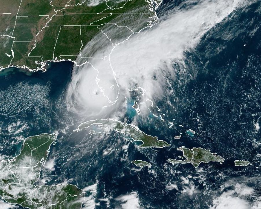
Hurricane Ian on Wednesday, Sept. 28
Image: NOAA
Hurricane Ian is approaching Sarasota County with maximum sustained winds of 155 mph—just two miles per hour short of Category 5 status.
"We're concerned for our entire community and are monitoring all areas," Jamie Carson, Sarasota County's communications director, said during a media update this morning.
"If you are in evacuation Levels A and B, leave now," she added.
Carson said that although the county is receiving preliminary reports of storm damage and power outages, officials are not able to assess damage right now—and won't be able to until the storm has passed.
"At this point, we're in the middle of [preparing] to have the storm impact us," she said. "Now is the time to think about life and safety."
A major marker for the county's operations is when winds reach 45 mph, which hadn't yet happened during Carson's update. At that point, emergency vehicles will be taken off the road and residents will be told to shelter in place. This will happen in waves, Carson explained, with South County emergency vehicles likely coming off the roads first and continuing north as the storm's bands move in.
She also emphasized the need to monitor dangerous storm surge. "Just because you don't see water, or have any ocean view, doesn't mean you won't be impacted by storm surge," she said. "You have to factor in rivers and other waterways, too."
The National Hurricane Center is currently predicting catastrophic storm surge inundation of 12 to 16 feet above ground level, with destructive waves between Englewood and Bonita Beach.
"We're working with our partners on the state level, at the National Weather Srvice and with local municipalities," Carson said. "We're not just thinking about what's happening now—we have to think about 10 hours from now, 20 hours from now, a week from now. We're thinking about the aftermath, too.
Carson added that she's heard people comparing the storm to Hurricane Charley, which struck Southwest Florida as a Category 4 hurricane in 2004. But, she said, "there's no comparison. This a stronger storm and there will be devastating impact to our community."
While some areas still have power, residents are encouraged to charge phones, laptops, tablets and any other communication devices that they need to be cognizant of where they are and stay on top of storm updates.
While phone service is available, the county's information line, 311, is available; those outside Sarasota County can call (941) 861-5000. In Manatee County, 311 is also available; those outside the county can call (941) 748-4501. You can also visit scgov.net and mymanatee.org for updates.


